Directions to Hocking Hills State Park
From Dayton, take U.S. Route 35 East through Xenia. As you approach Chillicothe, take the State Route 159/Bridge Street exit toward U.S. Route 23 North. Turn left on North Bridge Street/State Route 159. Follow State Route 159. Turn right on State Route 180. Turn right on State Route 56 East/State Route 180. Follow State Route 56. Stay straight to go on State Route 664.
For more information, go to parks.ohiodnr.gov/hockinghills or call (740) 385-6842.
At the end of last year, Buzzfeed came out with its “22 Stunning Under-The-Radar Destinations To Add To Your Bucket List In 2014.” The places on the list sound exotic: Orchid Island, Taiwan; Ometepe, Nicaragua; Rangiroa, French Polynesia.
All the destinations are thousands of miles away from Southwest Ohio, except for one: Hocking Hills State Park, the only place in the entire United States that made Buzzfeed’s list.
If you haven’t been there for years or, worse, if you’ve never been there at all, that’s a downright crying shame because Hocking Hills in Hocking County is the geological crowning jewel of Ohio and is fantastic to visit regardless of the season. I’ve been there on sultry summer days; also, when snow was on the ground.
Personally, my favorite times are in the spring and fall. When I was there this past April, the seasonal waterfalls were spectacular — I could hear the roar of the falls long before I reached them. There’s not so much water in the fall, but the turning color of the foliage and milder temperature makes hiking a delight.
The park is comprised of five separate non-contiguous areas: Old Man’s Cave, Cedar Falls, Ash Cave, Rock House and Cantwell Cliffs. Old Man’s Cave is the most popular destination of the five, but the unique features of each of the other four sites are definitely worth a visit.
I carry a backpack with plenty of water and opt for serious waterproof hiking boots when I’m on these trails. A boot with a thin sole lets me feel when I’m stepping on loose pebbles or twigs. In the winter and spring, the trails can be slippery because of ice and mud. In dry conditions, they can be slippery because of loose sand and in the fall, leaves can cover the rocks and roots that jut out of the trails.
I also carry food — usually a cucumber and almond butter sandwich, some chips, a piece of fruit and maybe some nuts. There are picnic tables and shelters at all the sites. After a day of hiking, a special treat is a double scoop of ice cream at Grandma Faye’s grocery and general store on State Route 664 about 1 mile west of Old Man’s Cave.
On my last day of hiking, I splurged for lunch at Hocking Hills Dining Lodge, also about a mile from Old Man’s Cave. The lodge has an extensive menu that includes pizza, entrees like center-cut pork chops and ribeye, lots of sandwiches, burgers and oodles of beer. I loved the Better Burger ($7.95) with cheddar (add $1) on a homemade potato bun with hand-cut fries on the side.
WHY HOCKING HILLS IS SO SPECIAL
Hundreds of millions of years ago, Hocking Hills was submerged beneath the Atlantic Ocean, the currents of which deposited vast amounts of sand and gravel. When the ocean receded, the sand and gravel bonded with silica and iron oxide to form a unique kind of sandstone found only in this part of the world. The middle layer of this Blackhand sandstone (named for a non-extant large black hand that American Indians painted out of soot on the side of a cliff) was very soft, and about 10,000 years ago glacial meltwaters carved out deep gorges, which are now teeming with lush vegetation, gigantic trees with exposed and twisted roots, and moss-covered boulders where chipmunks like to scamper.
Old Man’s Cave
Located off State Route 664, Old Man’s Cave isn’t a cave, but rather a large recess in a 150-foot-deep gorge, its name inspired by a hermit who lived here more than 100 years ago and whose remains are believed to be buried beneath the ledge.
Besides the large recess, there’s plenty more to see. The site is divided into five major sections: Upper Falls, Upper Gorge, Middle Falls, Lower Falls and Lower Gorge. If you take your time to look around, you’ll see it’s all fantastically beautiful — and don’t be surprised to see what resemble human-like faces peering out of many of the rock formations.
Near the Upper Falls is a don’t-miss natural whirlpool called The Devil’s Bathtub. Water flows down a tiered waterfall into a round basin. According to folklore, the basin is so deep that it reaches Hell; actually, it is only a few feet deep.
Just don’t plan on bringing a bar of Irish Spring and jumping in. The Devil’s Bathtub is off limits to visitors.
Cedar Falls
The Lower Gorge Trail from Old Man’s Cave will take you to Cedar Falls. Despite its name, there are no cedars, but plenty of hemlocks, which early Europeans mistook for cedar. The largest and most spectacular waterfall at Hocking Hills State Park is here, where the Queer Creek tumbles into the chasm.
Now, for the geeky part: Scientists and engineers will appreciate the path leading from the parking lot accessible from State Route 374. Called Democracy Steps, it was created by Japanese artist and architect Akio Hizume, who applied the mathematical principles of the Fibonacci Sequence as well as Penrose tiling into the design of the path.
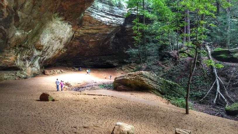
Ash Cave
A mile or so from Cedar Falls, after turning right on State Route 56, you won’t find any ashes in Ash Cave, and just like Old Man’s Cave, it isn’t even a real cave.
But when you reach the 700-foot-long horseshoe-shaped recess, you may feel like you’re on the set of a science fiction movie that takes place on Mars or some other desolate planet. You’ll also know you’re not alone — previous visitors have destroyed the primordial illusion by defacing the sandstone boulders by carving initials, names, other words and shapes into them. The enormous size of the recess, its peculiar quality of light, the sand and boulders, and the unauthorized modern-day hieroglyphics give Ash Cave a funky vibe.
Humans have been drawn to this place long before European explorers discovered enormous piles of ashes believed to have accumulated from centuries of fires. A group of sandstone boulders near the entrance of the recess is called Pulpit Rock because early Christian settlers used to hold church service here.
Ash Cave has a seasonal waterfall created by the East Fork of the Queer Creek. On prior visits, I’ve seen the pool of water below the waterfall shaped almost like a heart. Ash Cave is a popular site for weddings and a permit must be obtained from the park office (740-385- 6842).
There are two trails, an upper and a lower. The lower trail is paved, flat and wheelchair accessible.
Rock House
The only true cave at Hocking Hills State Park, Rock House is midway down a 150-foot cliff. It’s 200 feet long and features seven Gothic-like “windows.” American Indians used it for shelter and built ovens in some of the recesses. After European settlers arrived, it became a hiding place for outlaws and was nicknamed Robbers’ Roost.
I always carry a flashlight when I visit the cave because the floor is uneven; plus, in the wetter months, it can be slippery in spots.
The Loop Trail starts at the parking lot. I prefer going left, which descends much farther than the other route and provides a fabulous view of Rock House. But the price for that view is then having to ascend some very steep steps to reach the entrance of the cave.
Cantwell Cliffs
Not for the faint of heart, Cantwell Cliffs is both figuratively and literally a breath-taking experience. Located on State Route 374, it is the remotest of the five park sites, 17 miles away from Old Man’s Cave.
It’s a rugged trail that offers a heart-pumping descent through extremely narrow passageways — nicknamed Fat Woman’s Squeeze — to get to the bottom of the gorge.
This is a dangerous place so stay on the trail — not only for your own safety but for other hikers as well. During my recent visit to the cliffs, I’d descended into the valley when I suddenly heard a loud commotion and looked up in time to watch small boulders and rocks tumble down the recess because someone who’d gone off trail had stepped on a loose one. Fortunately, no one was in the path of the minor rock slide.
The ascent out of the gorge is very steep, and I’m always convinced that gravity here is denser by the time I make it back to the parking lot.
NEARBY SITES OF INTEREST
Conkle’s Hollow State Nature Preserve
Named after W.J. Conkle, who carved his name and the date 1797 into sandstone, Conkle’s Hollow is another woolly place located off State Route 374. Hikers have two trails to choose from: the scenic floor trail and the even more scenic but very challenging rim trail 200 feet above.
The lower trail is pleasant and will take about an hour, in and out. The 2.5-mile-long upper trail, which is pretty darn rugged, may take 2 or 3 hours to complete. The view from the rim is truly spectacular, but is no place for babies, small children, pets or spouses/boyfriends/girlfriends afraid of heights. I’ve witnessed the breakup of a couple on this rim.
Rock Bridge State Nature Preserve
Located outside the town of Rockbridge, just off U.S. Route 33, Rock Bridge is the longest of several dozen natural bridges in the state of Ohio. The stone arch is more than 100 feet long; 20 feet at its widest and about 6 feet at its narrowest; and 50 feet above a ravine.
A 1.75-mile long loop trail will take you to the bridge. Part of the trail is a boardwalk over a bog. The area can be muddy, so you may want to carry a walking stick.
About the Author